I'm a sucker for a good race report, in case you couldn't tell.
The list below is a compilation of my favorite race reports from other runners. Some are from important races in ultrarunning history, some are heartbreaking DNFs, and some are just plain funny.
Let me know if there is anything else I should add to this list, and I will keep it updated (In particular, I have had a hard time finding reports from elite women. Please send these my way if you find them.)
Entries marked with a 🔒 require a subscription to Ultrarunning magazine.
The Adirondacks are a beautiful mountain range. With a lot of silly names:
Dix
South Dix
East Dix
Nippletop
After running the Great Range Traverse with Alex Galasso in June, we exchanged a few ideas about ways to link up the funnier sounding peaks and create an FKT route that would tell the world, once and for all, that we had stopped maturing emotionally some time during middle school.
The result was the Giant-Dix Traverse.
Group photo from the summit of Giant
From left to right, Ryan Thorpe, Devang Patel, and Alex Galasso
The Giant-Dix Traverse
The final route was an aesthetic 25 mile point-to-point through the Giant Mountain Wilderness and the Dix Mountain Wilderness, summitting nine peaks, including six High Peaks: Rocky Peak Ridge, Giant, Dix, Hough, South Dix, and Macomb. We discussed whether to add East Dix (aka Grace Peak), but decided that we didn't want any out-and-back sections (We would then go on to make a massive navigational error that added an out and back. Best laid plans, and all that.).
GDT map, including our wrong turn late in the day
GDT elevation profile. Note the long, unnecessary descent between Dix and Beckhorn
The total elevation gain for the route was about 11,000 feet over a mix of single track and exposed technical ridges, putting this route roughly on par with the Great Range Traverse or the Presidential Traverse, at least on paper.
Goals for the Trip
Alex, Devang Patel, and I decided before this inaugural attempt that we were not going to red-line during this run. Devang was just coming off Eastern States 100 three weeks earlier, I had just run Ouray 100, and Alex didn't want to interrupt his Grindstone 100 training block.
Or, to put this in terms that are consistent with the route name, we were going to dick around a lot. That meant taking lots of pictures, stopping to eat, and just generally enjoying the scenery.
It also meant that we didn't do a whole lot of research on the route, aside from plotting it on Caltopo and saying, "yeah, that looks fun!" We then told our significant others that we would take "about ten hours" and asked them to meet us at the finish around then.
Giant Mountain Wilderness
We started at the East Trail parking area in the little town of New Russia. From there, it would be a 4,000 foot net climb westward to the summit of Giant Peak.
The first two miles were an easy ascent of Blueberry Cobbles, which was below tree line and offered no views. From there, the trail grew increasingly steep and rocky as we climbed Bald Peak and got our first good views of the day.
Having a snack at the summit of Bald Peak
A short scramble then brought us to Rocky Peak Ridge East Peak. If not for the howling wind and chilly morning air, this would have been a perfect spot to stop an enjoy the views.
View of Lake Champlain from the ridge
Some easy running brought us to Marie Louise Pond, whose trees were a welcome shelter from the elements. Alex and Devang sat by the water while I made use of the privy just off the trail. Then it was time to scramble up Rocky Peak Ridge proper and tag our first High Peak of the day.
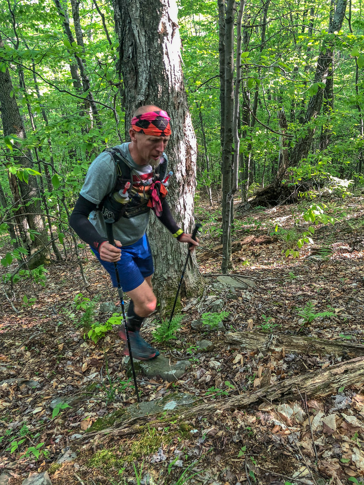
And another short scramble later, we were standing on Giant Mountain with 3:30 elapsed. We waited five minutes for a cloud to pass over, took a whole bunch of pictures (see, for example, the top picture in this post), and then started the 3,000 foot descent to Route 73.
Descending off the summit of Giant Mountain
The Ridge Trail was steep, but the footing was pretty good in the dry late summer weather. In the spring, this would have been a miserable slog with mud and overgrown trees. If nothing else, we had chosen the right weekend to run this route.
We got separated shortly below the summit as Devang and Alex stopped to take some pictures and I took a detour out to "The Bump," a side trail with some nice views. But eventually, we all met up again at Route 73.
Thus concludes the scenic but relatively uneventful first half of our adventure. Now let's get to the good stuff.
Dix Mountain Wilderness
We hopped onto the Dix Trail with 4:38 elapsed and about 11.6 miles into our 25 mile day. We were feeling good about finishing in under 10 hours and I briefly considered texting our loved ones that we would be done early. Thankfully, I never sent this text.
We stopped shortly after the trail head to filter water at Round Pond, then made quick work of the climb up to the intersection of the Old Dix Trail (ha!) as well as the three miles of rolling single track beyond that.
Mile 16 marked the beginning of the hardest climb all day, a 2,000 foot scramble up a rock slide and a boulder strewn gully.
Looking up the slide on Dix Mountain
We stopped at a creek part way up to have a snack. As we were getting up to go, Alex lost his footing and ended up sitting in the knee deep water. Unfortunately, I had started up the trail too early to see this in person and Devang wasn't able to capture the moment on camera. So it will just have to live on in our imaginations.
Alex looking more than a little sullen after his creek incident
After a seemingly endless climb, we finally reached the summit of Dix Mountain, the high point of our route at 4,840 feet. From here, it would just be a few miles of ridge running and then a steep descent to the finish.
Or so we thought.
Looking west toward the Great Range from the summit of Dix
Dicking around on Dix
After the requisite amount of dicking around, we made the quick traverse over to Beckhorn, took a few more pictures...
Foot selfie
...and then promptly fucked up our navigation beyond all hope.
You see, unbeknownst to us the Dix Range Trail, which continued over the remaining summits, is a separate entity from the Dix Trail. And, in fact, it is not an official trail at all but instead an unblazed herd path. None of this is clear from the cursory view of Caltopo which comprised our research into this route.
Consequently when I continued following yellow blazes after the summit, as I had been doing for the previous three hours, I inadvertently led us a mile and 1,700' vertical feet down the wrong trail.
Shit.
Silver linings: the Beckhorn Trail (our detour) was a beautiful and very pleasant trail to run on. But this didn't make up for the fact that we had budgeted our mental energy for another 2-3 hours, rather than the 4+ that it would now take us to complete the route. The slog back to the summit of Beckhorn was slow and very quiet. When we got back to the top, we just sat without looking at each other for 30 minutes.
This sums up our feelings
We debated calling it a day, but decided that it would be stupid to drop out this close to the end. So with heavy hearts and heavier legs, we set to work on the Dix Range Trail.
Now on unmaintained trails, our path was choked with overgrown tree limbs, and we found ourselves working for every step forward.
View of Beckhorn from Hough
Devang put his head down and charged ahead, only to run smack into a fallen tree. We made sure he was okay and resumed our run, only to stop two steps later when I smacked my head on the same stupid tree.
Spatial awareness and short term memory are not my strong suit.
View from somewhere along the ridge
The Dix Range had now exacted a toll on all of our egos and added a few scrapes and bruises for good measure.
But at least the scenery was nice
We tagged Hough, South Dix, and Macomb without further incident, stopping to commemorate each summit with some food and pictures.
Devang "celebrating" at the final summit
We then started the long steep descent down the Slide Brook Trail, which is more slide than trail. As a matter of fact, it was just about the worst terrain we were on all day, strewn with loose dusty talus which threatened to dislodge and chase us down the mountain with each step.
Slide Brook "Trail"
See video below for a better perspective.
After picking our way through the 1,000' half mile descent, we were finally back on a real trail. Devang celebrated by breaking into a run and immediately slamming into another tree so hard that I thought he knocked himself out cold.
The Dix Range Wilderness would not permit us to have the last laugh.
With renewed purpose (and ignoring my nagging questions like "do you know what day it is?") Devang sprang back to life and took off sprinting. Not wanting our concussion addled friend to wander off trail into the wilderness, Alex and I gave chase. Devang would go on to lead us to a string of 9 minute miles to end the day.
After 12 hours, 20 minutes, and 33 seconds, we collectively smacked the hood of Virginia's truck in the Elk Lake parking lot, signifying the end of our run. We had taken 2.5 hours longer than anticipated, and probably lost a few brain cells along the way.
But in the end, we achieved our goal of establishing an Only Known Time on a ridiculous and tough route.
...to Alex (Thorpe) and Virginia for waiting patiently for us at the finish, not knowing whether we were lost, dead, or had just decided to tack on another summit. These ladies even had a cooler full of beer waiting for us when we finished, which was vital to helping us forget the abuse we had just survived.
Thoughts on This Route
After some navigational issues and a lot of down time at summits, our final time was not at all competitive. A fast and motivated runner could easily cut this time in half. Best of luck to anyone who attempts it. We look forward to passing on the crown to the new Giant-Dix King or Queen.
Those of you who are regular readers of this blog will no doubt recall that I have a particular affinity for rugged mountain races. After years of trying to be a shitty version of Sage Canaday (#anysurfaceanydistance) I finally set aside all of 2019 to focus on mountain running and decided that Ouray would be the culminating performance in my year of mountain adventures.
With no road marathons or even particularly runnable trail ultras to prepare for, my training consisted almost entirely of hill repeats. If I wanted to do a VO2-max or lactate threshold workout, I just ran uphill a little harder. A typical training week was 40 miles with 12,000 feet of elevation gain, but the month leading up to race day was when I turned the intensity up a notch.
After proving that I still had some speed at "shorter" races with a 9 minute PR at Manitou's Revenge 54 miler in June, I started off July with a series of long back-to-back efforts in the White Mountains and then back in NJ, including:
All told, this two week block totaled 110 miles with over 52,000 feet of climbing. After an easy recovery week, Alex and I flew out to Colorado and I got in another 46 miles with 14,000 feet of vert at altitude in the seven days leading up to the race, including my first ascent of Long's Peak.
By the time I toed the line on the morning of July 26th, my legs felt strong, if not entirely fresh.
(Incidentally, I think feeling "fresh" at the start of a 100 mile race is overrated. How long does that fresh feeling last anyway? Maybe ten miles?)
The Hardest Trail Race in North America
"Please allow me to introduce myself / I'm a course of death and pain"
—Sympathy for the Devil, as sung by the Ouray 100 course
The Ouray 100 is a monstrously difficult course in the heart of the rugged San Juan Mountains of southwestern Colorado.
As a baseline for comparison, let's recap some of the harder races I've done over the years:
Clearly this race was in a different league than anything else I had ever attempted. In fact, Ouray's 42,000' of climbing is over 25% more than the neighboring Hardrock 100 (33k'), which has been the standard bearer for hard mountain races since its inception. The only North American trail races that approach this amount of elevation gain are some of the harder 200 mile races (Tahoe, Bigfoot, Franklins).
This elevation change is spread out over 14 distinct climbs and descents. Here's what that looks like on an elevation profile.
Ouray 100 elevation profile with estimated 40 hour splits
Due to its multiple out-and-backs and loops, the Ouray 100 course has been (often derisively) described as a cracked windshield. Here is my best attempt at annotating the course map to make it decipherable. The start and finish are in the town of Ouray, which is the little patch of gray in the upper right, while the main artery of the course is Camp Bird Road, which runs southwest from the town. Good luck interpreting!
Ouray 100 course map with 14 climbs labeled
Each of the sections labeled on the map is a significant climb and descent. Most of these sections are hard enough to be considered the crux of any other mountain race, which probably explains Ouray's 34% historical finisher rate.
Oh, and the altitude. Lest we forget the altitude...
The average altitude of the Ouray 100 is 10,239 feet above sea level. At this altitude, the effective oxygen content of the air is 30% lower than it is in my home state of NJ at 200 feet above sea level. And while my week of training at altitude helped a bit, I have since learned that it takes about three weeks for the body to produce new red blood cells. So despite being the fittest I've ever been, I was entirely un-acclimatized to the high altitude of this race.
The only way I could wrap my head around this race was to break it down into its constituent climbs. If I could convince myself that I was just doing a series of hard day hikes, then maybe I could maintain my sanity long enough to finish.
In that spirit, here is the story of my fourteen climbs at the Ouray 100.
Climb #1: Silver Basin
Section distance: 11.5 miles
Elevation gain/loss: 4,459 / 2,080
One of the many great things about the Ouray 100 is that it starts at the very civilized hour of 8:00am, as opposed to the ungodly 4 or 5am starts favored by most 100 mile races. This allowed me to get an unprecedented six hours of sleep the night before the race, which was critical since I would be awake for the next 50+ hours straight.
At the start of the race, a wave of 73 runners surged forward. I jogged slowly behind them and almost immediately found myself in last place. Similar to the start of Hellbender, I was comforted by the caliber of the runners nearest to me: Eric Hodges (13 Hardrock finishes), Chris Twiggs (14 Hardrock finishes), and Kirk Apt (record 24 Hardrock finishes). These dudes knew how to pace a 100 miler in the San Juans, so I was happy to be hiking at their pace.
A trio of badasses, followed by a solo dumbass
Photo by Chris Twiggs (center)
Kirk and Chris pushed ahead while Eric and I hung back and enjoyed the scenery. Over the next hour or so, he pointed out various rock formations, avalanche paths, and points of interest along Camp Bird Road. But eventually, even this 70-year-old's pace felt too aggressive for me, so I let him go ahead, much to the dismay of my fragile male ego.
I would eventually catch up to Ben Foreman, who was running his first 100 mile race (go big or go home, I guess), and we would keep each other company for the rest of the climb. Ben and I only spent a few miles together, but we would pass each other in opposite directions for the rest of the race, and I was always struck by how positive he seemed to be, even during low points. He would go on to finish in 50 hours. Note to self: be as positive as Ben.
Canyon creek still filled with avalanche debris from the spring
A few miles in, we passed Camp Bird Mine, which famously produced $1.5 billion worth of gold and silver from 1896 to 1990. As the town names in the region suggest (Ironton, Silverton, Telluride), the San Juans were once the epicenter of metal production in the United States, and the abandoned mines, railways, and tailings can still be seen throughout the mountain range.
It was during this section that we crossed the first of the major snowfields that the course would throw at us,. The midday weather was warm, and we were easily able to kick steps into the snow. I was even able to glissade buttslide back down, to the amusement of the runners around me. The wet butt that resulted from this stunt was well worth the 10 seconds of amusement.
Snowfield on the trail to Silver Basin
Before I knew it, I was back at Camp Bird aid station and ready to start the second climb. I had a bit of an altitude headache, but it wasn't affecting my pace or mental state just yet.
Climb #2: Chicago Tunnel
Section distance: 4.4 miles
Elevation gain/loss: 2,218 / 781
The climb to Chicago Tunnel was when I finally started to catch up to the rest of the runners after their aggressive start. Having other people to enjoy the scenery with made this climb fly by, despite the increasingly rocky trail conditions. This would end up being a theme of the race: the trails get increasingly more difficult from the start to the finish.
Bib punch at Chicago Tunnel
Chicago Tunnel was the site of an old mine shaft, and I took a minute to inspect the railway tracks leading deep into the heart of Chicago Peak.
Old tracks leading into Chicago Tunnel
It boggles the mind imagining that people spent years of their lives in narrow tunnels like these, filling carts with ore by lamplight.
Climb #3: Fort Peabody
Section distance: 5.9 miles
Elevation gain/loss: 2,063 / 2,309
The climb to Fort Peabody was the high point of my race, literally and figuratively. Imogene Pass Road, which connects the towns of Ouray and Telluride, had just been cleared of snow the day before the race. The plows had left behind a massive snow canyon that was just wide enough for a Jeep to drive through.
Snow canyons on Imogene Pass Road
I had seen pictures of roads like this before, but I had always wanted to walk through one. Let me tell you, it was just as cool as I had hoped. I took dozens of pictures and spent long stretches brushing my hand against the snow wall as I hiked up to the pass.
Once at the top of the pass, we left the road and made a sharp turn onto a knife edge rock formation. From this precarious spot, we could see Telluride to the west and Ouray to the east, both more than 5,000 vertical feet below us. Thunderstorms rumbled softly in the distance, and the sky turned an ominous shade of gray.
Knife edge from Imogine Pass to Fort Peabody
Legendary race photographer and mountain racer Howie Stern was perched on the ridge taking pictures. He is responsible for the shot at the top of this post, which is possibly the best picture ever taken of me.
I stopped at the top of the ridge to punch my bib at Fort Peabody, the highest military post in the US at 13,365'. Back in 1904, it served as a Colorado National Guard sentry post during a statewide labor dispute between the Western Federation of Miners and their employers.
I also got to pet Howie's pet Malamut, Miki. So things were going pretty well all around.
I felt so invigorated by the view from the pass that I hardly even noticed the 2,300 foot descent. I reached Richmond aid station, fueled up, and charged up Richmond pass, excited to see Alex for the first time since the start of the race.
Climb #4: Richmond Pass 1
Section distance: 6.0 miles
Elevation gain/loss: 1,763 / 3,024
As I began the climb up Richmond pass, I contemplated how best to inform Alex that I was actually a superhero who was impervious to pain and fatigue.
That's when the terrain got rough.
The lower slopes of Richmond Pass were covered in loose talus, making the footing difficult. The upper slopes were still blanketed in a thick layer of snow after a historically bad winter. Softening in the afternoon sun, the snowfields had the consistency of mashed potatoes, and my trekking poles occasionally sunk in up to their handles.
The "trail" up Richmond Pass. Note the runners in the snow field ahead.
I passed Walter Handloser in this section, who as you may remember from my Hellbender report, is attempting to run fifty 100 mile races in a calendar year. He was sitting on the side of the trail working through a rough patch, and my offerings of food and shitty jokes were not enough to pry him from his perch. Seeing someone so strong struggle with the climb made me nervous, but it was a small comfort knowing that I wasn't the only one who wasn't enjoying this section.
(Ever the model of consistency, he would go on to pass me hours later and finish his 28th 100 miler. As of this writing, he has completed 33 in the first 35 weeks of the year. Go get it buddy!)
View of the Red Mountains from Richmond Pass
At the top of the pass, we were greeted by a jaw dropping view of the Red Mountains. I paused for a few photos before tiptoeing down the incredibly steep 3,000 foot descent to Ironton. I reached the aid station in fine physical condition, but feeling a bit less invincible than I had felt two hours earlier.
Climb #5: Corkscrew Gulch (CCW)
Section distance: 8.2 miles
Elevation gain/loss: 2,782 / 2,782
Seeing Alex at Ironton immediately put a pep in my step. With a kiss, some new socks, and a handful of food (avocado wraps - yum!) I was on my way around Corkscrew Gulch for the first time, ready to circumnavigate Red Mountain Number 1.
The Red Mountains looked spectacular in the early evening sunlight, and I paused frequently for pictures. even wandering a quarter mile off course at one point because I was so distracted by the scenery.
Late afternoon view in Corkscrew Gulch
Normally, going off course would bother me, but it was only a three minute excursion, and the resulting photo (see above) was worth the lost time.
I took the descent back down to Ironton slowly, still recovering a bit from Richmond Pass. I got to the aid station just as the last rays of sun disappeared for the night.
Climb #6: Corkscrew Gulch (CW)
Section distance: 8.2 miles
Elevation gain/loss: 2,782 / 2,782
Now to do the exact same loop, but in reverse and in the dark...
Within minutes of leaving the aid station, thunder rumbled overhead and a light rain started to fall. Within a few more minutes, that light rain had turned into a steady downpour. I put on my rain shell and kept moving.
By the time I reached the top of the climb, a full fledged thunderstorm was raging in all directions, and the rain and fog were so intense that I could barely see the ground in front of my feet. I caught up to Chris Twiggs, and we almost immediately lost the jeep road that we were following.
"Do you see the trail?" I shouted to him through buckets of rain.
"It's a jeep road, not a trail," he shouted back.
"Well I don't see the jeep road either," I informed him.
He pondered a moment and then offered the kind of sage wisdom that only comes from 14 years of racing experience in the San Juans...
"SHIT! I hate this shit!"
We pulled out our phones and checked the course, map, realizing to our shame that we were right next to the road. The fog had made it indistinguishable from the random rock piles in all directions.
It has been pointed out to me that my sense of direction is lacking, to use a generous term. But losing a jeep road while running with a 14x Hardrock vet might have been a new low.
Snow canyons on Corkscrew Gulch
Photo by Avery Collins in much nicer weather
Now back on course, my primary concerns were to reach Ironton without being struck by lightning or dying of hypothermia. I put my legs into high gear and hammered the next three miles. As I reached our rental car, I shouted to Alex to turn on the engine and blast the heaters.
Climb #7: Richmond Pass 2
Section distance: 10.2
Elevation gain/loss: 3,125 / 4,075
"Yeah, the wind is blowing
Volcanoes blowing, my lungs are blowing
Over and over"
—Jack White, Over and Over and Over
It was time for some damage control.
Safely inside our monstrously oversized SUV, I set to work removing every article of clothing and replacing it with something warmer. When I at last emerged into the night, I was bundled from head to toe in thermal and waterproof layers.
Charging off into the storm
Photo by Alex
I grabbed some solid food from the aid station and waddled slowly toward the Richmond Pass trail head. This section had been rough during the mild sunny daylight hours, and I expected nothing less than a full fledged sufferfest on the way back.
I was quickly joined by two other racers, whose names I have since forgotten. They had wisely hunkered down at the Ironton aid station to wait out the storm. Now that it was starting to clear up, they were ready to charge up the climb.
Unfortunately for my slow ass, they decided that the pass was too dangerous to travel over alone, and they informed me authoritatively that we were all going to climb over it together.
"I'm not moving well," I pleaded with them, "I'll be fine. Just go ahead and someone else will catch up to me."
But they wouldn't hear my excuses, and I was too tired to resist any further. Over the next two hours, I red-lined to keep up with them, stopping every 10 minutes to politely ask them to fuck off and let me die on this mountain alone.
Snowfields on Richmond Pass as seen during the day
When we finally reached the top of the pass, I celebrated by emptying the contents of my stomach directly onto the trail in front of me. I had been breathing so hard for so long that I actually pulled an abdominal muscle, which I didn't know was possible. For the remaining 30 hours of the race, I would not be able to run without feeling like my stomach was tearing itself in half.
The snowfields had frozen over in the chilly night air, but the footing was still manageable thanks to the footsteps that runners had left the previous day. When we reached the end of this technical section, the other runners pushed ahead and I was finally allowed to run on my own.
To my well-intentioned guardian angels: Thanks for looking out for me, but I am pretty comfortable being alone in the mountains. Please just let me go my own pace next time.
Climb #8: Alpine Meadow Overlook
Section distance: 5.1 miles
Elevation gain/loss: 2,361 / 2,361
I staggered into the Weehawken aid station almost five hours after leaving Ironton. I had not been able to eat or run at all since the top of the pass, and it looked like my race finish was in jeopardy.
I would find out later that dozens of runners dropped out at Ironton, either unwilling to go out in the storm or too hypothermic to continue.
Sunrise over Ouray from Alpine Meadow Overlook
I spent ten minutes sitting in a camp chair trying to force down a bowl of ramen and a cup of Coke. I then informed a volunteer that I was going to take a quick nap and try to reset myself a little bit. She responded that I was too close to the cutoffs for a nap, and I needed to get moving.
"Go fuck yourself, I'm taking a goddamned nap. Okie dokie!" I responded
For the second time that night I lost an argument, and I soon found myself heading up the Alpine Meadow Overlook. Despite being a bit overgrown, this climb was one of the milder sections of the course. The footing was good, and I had a nice view of the sunrise over Ouray before trotting back down the way I had come.
Climb #9: Hayden Pass 1
Section distance: 7.1 miles
Elevation gain/loss: 3,611 / 2,749
Hayden Pass was another hellishly steep section of trail, but at least the views made the time go by pretty quickly. Long portions of the trail traversed an exposed ridge line, and the early morning sunlight was a welcome break from the long night.
Looking a little frazzled after a long night
Photo by Alex
I stopped at a few streams to filter water, but otherwise just marched on, seeing only a handful of runners passing in the opposite direction. I reached the Crystal Lake aid station at 10am on Saturday morning, 26 hours elapsed in the race, but still with 36 miles left to go.
Morning view of Crystal Lake
Photo by Alex
Alex greeted me here with a bagel and coffee, because she is a perfect being sent from heaven who knows exactly what I need at all times.
I gratefully accepted her divine offering of breakfast food, and followed it up with some Coke and other snacks from the aid station while I enjoyed the view of Crystal Lake.
Want to make a NJ boy happy? Find him a bagel in rural Colorado.
Photo by Alex
With some calories finally in my system, I left the aid station in good spirits but still unable to run consistently due to my various stomach issues.
Climb #10: Hayden Pass 2
Section distance: 8.6 miles
Elevation gain/loss: 2,628 / 4,553
More steep climbing, more panoramic views. You get the idea. Oh and I got to pet Howie Stern's dog again!
Views from Hayden Pass
Photo by Howie Stern
However, once again nature decided to throw a wrench in our race plans. With a sudden loud BOOM, a light show played out directly overhead just as I had crested the high point of the pass. Rain poured from the sky as if god himself was powerwashing us feeble runners off his mountain. A few minutes later I noticed that the raindrops were stinging my skin as they hit, and realized that I was being pelted with hail.
I needed to get below treeline fast! Once again I found myself hammering downhill as fast as my ragged respiratory muscles would allow. The trail turned into a river of muddy water, carrying debris and little hail pellets past me as I ran. It was downright apocalyptic.
Then, as quickly as it began, the storm ended, the sun came out, and birds started chirping.
Mountain weather is weird.
Climb #11: Twin Peaks
Section distance: 6.3 miles
Elevation gain/loss: 3,450 / 3,505
The descent from Hayden Pass finally took us back to the town of Ouray, from which we would begin each of the remaining out-and-back sections. Now over 30 hours into the race, I felt like I had just finished a 100 miler, but I still had at least 15 hours and four climbs left to go.
The first of these was an extremely steep and technical climb up Twin Peaks. At this point in the report, I'm sure the words "steep" and "technical" have lost their meaning, but portions of this climb were legitimate rock scrambles.
Check out Jay Lemos climbing this thing back in 2017 (skip to 1:23 for the Twin Peaks scramble).
Having done plenty of rock scrambles in my training, I was pretty happy to have the opportunity to use some different muscles. However, I will say that it's crazy to make runners pull legitimate rock climbing moves at mile 77.
Hole punch at the top of Twin Peaks
I took a minute at the top to appreciate how cool that section of trail had been and to take in the amazing views one more time, and then scampered down to the Silvershield aid station.
Climb #12: Silvershield
Section distance: 4.0 miles
Elevation gain/loss: 1,968 / 1,919
I refueled quickly, gave Alex another big sweaty kiss, and then headed back up. I was starting to smell the barn (incidentally, also starting to smell like a barn), and I wanted to get this thing done.
Coming into Silvershield Aid Station
Photo by Alex
Silvershield was an easy climb by Ouray standards, but it was also the least scenic climb in the race. Aside from a set of dinosaur tracks (no, really!) near the top, this trail didn't offer any benefits other than making the race an even 100 miles with 40,000+ feet of gain.
Dinosaur tracks on the Silvershield Trail
With no distracting scenery, I powered through and reached Fellin Park 30 minutes ahead of schedule, feeling more energetic than I had in a while. The sun had just set for the second time.
Climb #13: Chief Ouray Mine
Section distance: 6.7 miles
Elevation gain/loss: 3,399 / 3,399
Chief Ouray Mine probably would have been a very pretty trail in daylight. At night, however, it was just an endless series of switchbacks with no views and only the occasional 50 mile runner zooming by me. I quickly began to feel the accumulated effects of 40+ hours with no sleep.
My sleep deprivation expressed itself in a few ways. The most obvious of which was that I literally started to fall asleep while walking. At one point I went to plant both poles and briefly lost consciousness before they hit the ground. I missed completely and my arms swung back wildly. I woke up just in time to save myself from face planting into the ground. Thankfully the adrenaline rush from this almost-swan-dive was enough to keep me awake for the remainder of the section.
The more subtle (to me) effect of sleep deprivation was that I began to hallucinate. At first I thought there were smiley faces drawn on every single rock on the trail. I thought maybe some local artists had hiked up and decorated the rocks as a hobby. It also looked like the trees and bushes had been trimmed to resemble smiling faces or animals. Every tree stump became a moose or a lion crouched on the side of the trail.
It was not until after the race, when I excitedly asked another runner about all the smiley painted rocks, that I realized just how vivid and prolonged my hallucinations were. But at least they were fairly benign compared to the stories I've heard from other runners.
Somehow I made it back down from this climb without sleepwalking off the mountain or being committed to an insane asylum. Now all that was left was one last climb.
One. Last. Giant. Climb.
Climb #14: Bridge of Heaven
Section distance: 10.6 miles
Elevation gain/loss: 4,844 / 4,844
"The struggle itself toward the heights is enough to fill a man’s heart. One must imagine Sisyphus happy." —Albert Camus, The Myth of Sisyphus
As if the course wasn't difficult enough, race director Charles Johnston threw us one last gut punch at the end of the race. Bridge of Heaven is the longest single climb on the entire course, ascending a whopping 4,800 feet from the town of Ouray to a mountain pass at 12,308'.
With nothing else to save my legs and lungs for, I charged into this climb... and still only managed 50 minute miles. I think my lungs were pretty spent even though my legs still felt strong.
Last few switchbacks on Bridge of Heaven
The lights from Ouray faded into the distance as we ascended into the cloudy night. Five miles and four full hours later, I finally reached the top of the pass, just as the sun was peaking over the horizon. The scenery was breathtaking. I had a snack, took pictures in every direction, and then set to work on the descent.
Sunrise from Bridge of Heaven
There were 46 hours and 15 minutes elapsed in the race, which meant that I had 1:45 to cover almost a vertical downhill mile if I was going to finish in 48 hours. For the first time in many hours, I started to run, stomach spasms be damned!
I passed a handful of runners, some still climbing, some descending, but all very supportive of me and of each other. One of the overlooked aspects of this race is that the out-and-back sections mean that the mid-pack runners can cheer the elite runners on, and vice versa.
With 30 minutes left, I still had another 1.5 miles and 1,000 vertical feet to get to the finish line. I hammered the rocky downhill, thankful for the many hours of hill repeats that had battle hardened my quads over the previous months.
I reached the road and had 12 minutes to go the last half mile. All I needed to do was jog it in. And jog I did, hoping desperately that I wouldn't vomit as I entered Fellin Park for the last time.
Got that sweet hardware!
Finally, after 47 hours, 55 minutes, and 48 seconds, I crossed the finish line of the Ouray 100 in 19th place and 3rd among East Coasters. Of the 73 runners that started, only 32 would go on to finish.
I had beaten my distance PR by a mile, my elevation PR by 18,000 feet, and my time on feet PR by 19 hours. What a goddamned ridiculous beautiful adventure!
I have to start by thanking my beautiful, wonderful, supportive wife Alex, who crewed me by herself for 48 hours. Although we rented a house close to the course, she was not able to sleep because she was too busy watching my SPOT tracker beacon move slowly on a map.
Even after the race was over, her crew duties were not, as she had to pack our gear and herd my bloated sleep deprived corpse to a new hotel, reminding me periodically to stop squishing my swollen cheeks and put on my shoes already.
I'm proud of the fact that I became one of a handful of east coasters to finish this race, although I certainly left some time on the course due to my own lack of warm clothing on Corkscrew Gulch and my inability to go my own pace over Richmond Pass. I also realized that I need to acclimate for more than a week if I ever get a chance to run Hardrock. Day hiking at 10,000 feet and running for 48 hours at 10-13,000 feet put very different amounts of strain on the body.
The one thing that I'm absolutely pleased with is how well my legs held up. At no point in the race was I limited by muscle pain or fatigue, and even afterwards I was able to go up and down stairs comfortably (though I did get out of breath very easily). Clearly my steady diet of hill repeats had their intended effect. Now I just need to get faster!
The Hardest Race in North America?
Let's come back to my opening statement for a moment.
I believe that Ouray is the hardest trail race in North America, based on it's insane elevation gain, high altitude, and technicality. However, there are a handful of off-trail races or adventure runs that are certainly harder.
Barkley Marathons: 130 miles, 66,000' of gain, almost entirely off trail, and runners can only use a map and compass to navigate. This is the original impossibly hard race, and it gets harder every year. But it's not a trail race.
Baldy Marathons: 100 miles, 50,000'. Billed as a west coast version of Barkley, Baldy has only seen one finisher in 8 events.
Highlander 100: 100 miles, 63,000'. So difficult that the race will be canceled if anyone ever finishes it. There can only be one! (finisher)
WTF 100: 108 miles and 48,000', with about 80 miles off trail. A new Catskill race from the twisted mind of Mike Siudy. I'll let you guys know whether this is harder than Ouray when I attempt it in October. Still not a trail race though.
Nolan's 14: ~100 miles, 40,000'. On paper, it might look similar to Ouray, except that large portions are on class 3 or class 4 terrain, and the average elevation is much higher (every summit is at least 14,000 feet up!).
The only trail races that I believe come close to Ouray are:
Hardrock: 100 miles, 33,000'. The older, more prestigious brother of Ouray. Hardrock's trails are more remote and slightly higher on average. However, Ouray's 9,000 feet of additional climbing probably give it the edge. If I ever get into Hardrock, I'll let you guys know for sure.
Cruel Jewell: 106 miles, 33,000'. Low altitude, but humid and no views. This race sounds more mentally challenging, but its 48 hour cutoff is generous.
HURT: 100 miles, 25,000'. Humid, muddy and root covered trails, and a 36 hour cutoff give this race a very low finisher rate.
Plain: 100 miles, 20,000'. Not the hardest trails, but entirely self supported. Runners have access to their drop bags once during the race, but are otherwise on their own for up to 36 hours in the Cascade Mountains.
If you know of a race that's harder than Ouray, be sure to leave an angy profanity-laden comment below. Thanks for reading this stupidly long report!